Exploring The Forest On Our Doorsteps
Over the last 120 years, Sullivan’s Island has done something very rare for a barrier island: it has grown. Local author Stratton Lawrence takes a walk through the almost 200-acre maritime forest that has sprung up on this “new” land to discover its secrets and understand its purpose. Photos by Hunter Mcrae.

Christopher Robin may have had his hundred acre wood to roam, but the children of Sullivan’s Island can do Pooh and the gang one better—a two-hundred acre wood.
Beginning with the completion of the Charleston jetties in 1890, Sullivan’s Island has accumulated sand as it backs up at the mouth of Charleston Harbor. The jetties—massive piles of rocks that extend three miles out into the ocean—funnel sand toward Sullivan’s Island that would otherwise accumulate in the mouth of the harbor, making it one of the only barrier islands on the entire East Coast to be currently growing.

An accreting island has meant more room for new houses and roads. Ion Avenue was once beachfront, only to see two more rows of homes built in front of it throughout the 20th century. In 1991, however, the Town opted to place its remaining undeveloped beachfront land into a conservation easement with the Lowcountry Open Land Trust. At the time, this constituted 87 acres of beachfront property that in a quarter-century has grown to over 190 acres. This new land has developed into a thriving maritime forest—a rare and quickly disappearing habitat along the rest of the South Carolina coast.

The bulk of the forest lies between Station 18 and Fort Moultrie on the island’s west end. To visit its heart—and encounter its array of wildlife—take a walk down the sandy path that begins at the corner of Station 16 and Atlantic Avenue. Within moments, you’ll be transported to a serene, natural world that’s stunning in both its beauty and its very existence in such close proximity to a major metropolitan area.
A FRAGILE BUT PLENTIFUL ECOSYSTEM
“It’s magical,” exclaims Sullivan’s Island Mayor Pat O’Neil as we stride under a canopy of oaks, magnolias and myrtles on a warm April evening. O’Neil—elected in 2015 on a platform that included the principles of “conservation and preservation”—has been instrumental in the community’s efforts to preserve the forest for wildlife and public enjoyment, including a forthcoming project to add short boardwalk sections to trails that cross through critical wetland and dune habitat.
“We don’t want to put up a tourist sign ... but we do want people to come and enjoy this forest,” O’Neil says.
He’s joined in those efforts by conservation groups like the Sullivan’s Islanders, who host educational nature walks and have produced a short series of videos highlighting the ecological importance of the forest.
“If you disturb one thing out here, you disturb everything, because this is such a harsh environment,” explains Julia Khoury, a member of the group’s steering committee, citing the salty air, frequent wind and sandy soil that makes water retention a challenge.
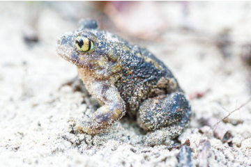
As the land ages, however, topsoil forms as smaller plants decompose, creating a base for maturing wax myrtle trees, as well as the occasional pecan and cedar—both signs of a healthy, established forest. Throughout parts of the forest, seasonal wetlands now exist in the depressions between rows of former beachfront dunes, serving as critical nurseries for aquatic animals. Walking along these soggy areas’ boundaries, we quickly find two species of toads—Eastern Spadefoot and Southern—making their way along the forest floor.

Amphibians like these—along with the insects they dine on— form the basis of a food chain that supports an incredible array of birds and small mammals, all the way up to the coyotes that now live in the forest, filling the role of apex predator that native red wolves once played. O’Neil points out that in the years since the coyotes have established themselves, the rat population—common on barrier islands like Sullivan’s—has decreased dramatically, as have the numbers of feral cats, whose habit of hunting songbirds can devastate their numbers.

Nathan Dias, Julia Khoury and Pat O’Neil, Mayor of Sullivan’s Island, take a stroll through the maritime forest.
In addition, as the forest grows, the tree canopy blocks the lights of houses from sea turtles nesting on the beach, and their shade clears out the vines and shrubs that can harbor rodents that thrive in a developing or freshly pruned ecosystem.
Although rodent control is a real benefit of the forest to the human residents of Sullivan’s Island, the forest’s largest beneficiaries are the birds.
FOR OUR FEATHERED FRIENDS
During the early 2000s, Nathan Dias lived in San Francisco, seeking inspiration from the vibrant bird conservation organizations throughout California. However, the lowcountry native was distraught over the overdevelopment he witnessed whenever he returned home.
“I was appalled at how development was running wild around Charleston, and nobody was really speaking up for the birds. I couldn’t stay away and let things continue like that,” Dias recalls.
In 2004, the computer security expert returned home to pursue his true passion— bird conservation. He founded the Cape Romain Bird Observatory, and for the last decade has served as a watchdog and advocate whenever a building project threatens to destroy crucial bird habitat.
With plans in place to remove the last remaining forest at Patriots Point, along Charleston Harbor in Mount Pleasant, Dias emphasizes that the Sullivan’s Island tract is the only stretch of forest left for migrating songbirds on the north end of the harbor.
“When birds are headed south during the fall migration, Charleston Harbor is a big natural barrier,” Dias says. “They won’t cross in the daytime for fear that a hawk or falcon will catch them out in the open, and when it’s bad weather at night—rainy, windy or cloudy—they don’t like flying over big bodies of water. So, they stop along the north rim of the harbor and accumulate in massive, fantastic numbers.”
In the spring, the same birds bed down to rest and eat in the forest after crossing the harbor—meaning that twice a year, Sullivan’s Island becomes alive with colorful songbirds like Painted and Indigo Buntings and Yellow-throated Warblers.
“During the migration, the Sullivan’s Island forest is one of the most popular places for songbirds in the state,” Dias says, adding that it’s a “hard and fast rule that large bodies of water need habitat on their margins.” Without that, he warns, we’ll see further reductions in the numbers of songbirds along the entire East Coast.
For the amateur birder, visiting the woods is made all-the-better by the surrounding views. Emerging from the forest near Fort Moultrie, hikers find themselves in an open shrubland among dunes filled by sea oats, prickly pear cactuses and wild blackberries, with clear views across the harbor to Fort Sumter ahead and a forest canopy full of birds behind.
THREATS TO A SUBURBAN WOODLAND
Throughout the forest, we encounter plant after plant with a story to tell. There’s the spiky-trunked “toothache tree,” with bark that served as a natural salve for the dental ailments of Native Americans and Colonial settlers and the leaves of which are the food source for our largest native butterfly, the Giant Swallowtail. Growing next to it, there’s the sugarberry tree, often called hackberry, with sap that sustains Emperor and Tawny butterflies.
A rabbit hops across the trail in front of us, and a green tree frog gives its distinct chirp from 20 feet away through the trees.
But this idyllic forest isn’t without its challenges. Some wetland areas harbor Chinese tallow, a fast-growing tree still sold for landscaping purposes that has wreaked havoc on coastal wetlands, choking out native plants and drying the soil. Pampus grass, a fastgrowing invasive species that outcompetes native dune grasses, moves in quickly after wax myrtles and other shrubs are pruned. Even the pretty and abundant wisteria along the forest’s primary pathway is an invasive weed that’s displacing indigenous plants, and thus stealing resources from songbirds and other species.
Human intervention also plays a role. Although the land—and any newly accreted land—is protected by the 1991 agreement with the Land Trust, some homeowners want to trim the forest where it abuts their property. A 2010 lawsuit against the town is still being mediated, and a compromise may include a transition zone that allows for more aggressive pruning in the area of the forest closest to the homes.
Although conservationist Dias sees any efforts to reduce the size of the established forest as shortsighted, he celebrates the fact that much of the wooded area adjacent to National Park Service-owned Fort Moultrie is safe from chainsaws.
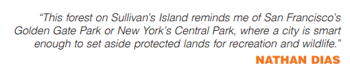
“This forest on Sullivan’s Island reminds me of San Francisco’s Golden Gate Park or New York’s Central Park, where a city is smart enough to set aside protected lands for recreation and wildlife,” Dias explains, adding that in this case, the wide forest serves as a powerful natural buffer from a hurricane’s storm surge. “Protecting this was a visionary move in 1991.”
Although Hurricane Hugo in 1989 did cause devastation on Sullivan’s Island, its effects could have been even worse without a healthy dune and forest ecosystem. In fact, it was after that storm that the people of the island came together to protect their growing natural asset. Thanks to that generation, today’s community leaders like O’Neil, Khoury and Dias hope to pass on an appreciation for the maritime forest to the next generation.
“Too many children today have what I call ‘nature deficit disorder,’” Dias says. “We need to get our kids’ faces out of screens and into the woods to run and play.”
With 200 acres in their backyard, who knows? Maybe the next Winnie the Pooh will emerge from the imagination of a young writer from Sullivan’s Island.